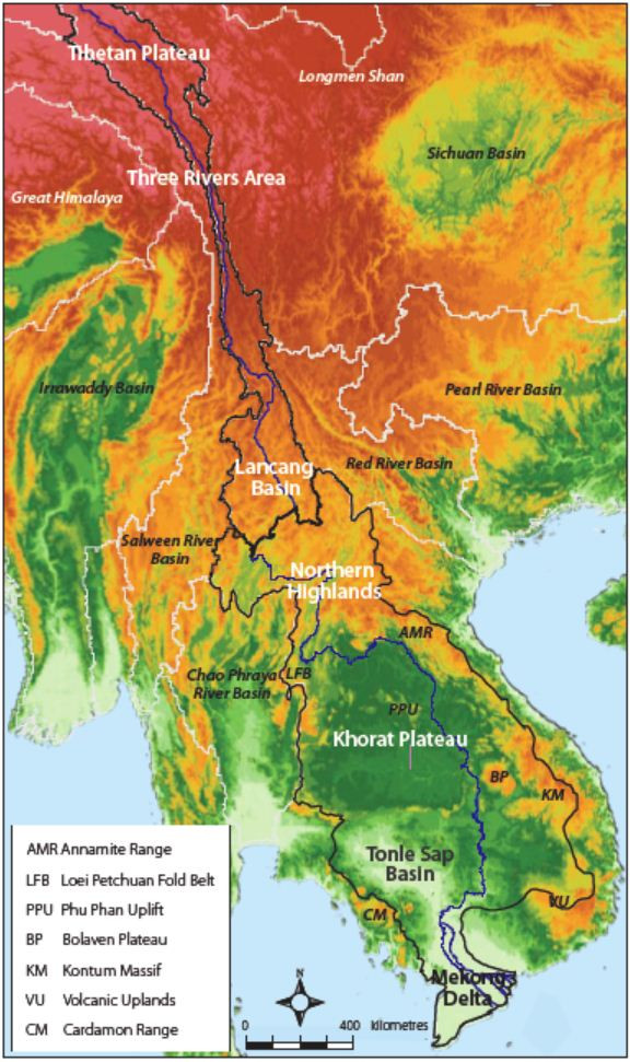
Geographic Regions
The Mekong River Basin can be divided into two sections. The Upper Mekong Basin comprises an area in China where the Mekong is known as the Lancang River, which makes up 24% of the total Mekong Basin (190,800 km2). The Lower Mekong Basin comprises the area downstream of the border between China and Lao PDR.
Upper Mekong River Basin
Tibetan Plateau
The Tibetan Plateau extends over 2.5 million km2, of which about 316 km2 drain into the headwaters of the Mekong River. Located at 5,160 m above sea level, the plateau is the source of the Mekong and the most densely glaciated region on earth.
Three Rivers Area
The Three Rivers Area is a rugged mountainous region in China where the Mekong runs alongside two of the region’s other great rivers: the Salween and the Yangtze. Separated from the other rivers by high mountain ranges, the Mekong flows through a deep ravine, with no significant tributaries in this stretch.
Lancang Basin
Located south of the Three Rivers Area, this highland and plateau area in China is still relatively elevated (2,000-3,000 m above sea level), transitioning to mid- and lowland reaches as the Mekong flows down a steep gradient, broadening as it goes. Small tributary catchments drain into the river from both sides of the mainstream.
Lower Mekong Basin
The Lower Mekong River Basin is functionally subdivided into four geographic regions. With a total catchment area of about 571,000 km2, the basin covers a large part of northeastern Thailand, almost the entire countries of Lao PDR and Cambodia, and the southern tip of Viet Nam.
Northern Highlands
The Northern Highlands form the upland region, covering northeastern Myanmar, northern Thailand and the northern areas of Lao PDR. Large tributaries, including the Nam Ta, Nam Ou, Nam Soung and Nam Khan, enter on the Mekong’s left bank, while the Nam Mae Kok and Nam Mae Ing enter on the right bank.
Khorat Plateau
Lying largely within northeastern Thailand, the Khorat Plateau is a vast, low-lying terrain consisting mainly of sediment and eroded bedrock and surrounded by a rim of highly resistant sandstone. Here the Mekong River is joined by the Songkhram and Mun Rivers on the right bank and the Nam Ca Dinh, Se Bang Fai, and Se Bang Hiang Rivers on the left bank.
Tonle Sap Basin
The Mekong River flows through a broad valley to the east of the Khorat Plateau and enters the Tonle Sap Basin just north of Pakse. The Tonle Sap Basin is a large alluvial plain surrounded by hills. At the southern end of the basin, the mainstream breaks up into a complex network of channels that branch off and reconnect. The western and central parts of the Tonle Sap Basin make up the Great Lake.
The Great Lake
Located in the Cambodian floodplains, the Tonle Sap Lake or Great Lake is the largest freshwater body in Southeast Asia.
During the dry season, the Great Lake drains into the Mekong River via the Tonle Sap River. During the wet season, the high flows in the Mekong River cause the Tonle Sap River to reverse its flow direction to flood the Great Lake. During the peak of the flood season, the Great Lake’s surface area increases six-fold, from around 2,500 km2 to around 15,000 km2, and its volume increases from around 1.5 km3 to around 60-70 km3. At the end of the wet season, the flow of the Tonle Sap River reverts to the downstream direction, draining excess water off the inundated floodplain surrounding the Great Lake.
This hydrological cycle supports the lake’s rich biodiversity, including fish, wildlife and plants on which many local communities rely for their livelihoods. For example, in Cambodia, 40% of the population depends on the Great Lake and its floodplains for both income and food supply.
Mekong Delta
Near the Cambodian capital Phnom Penh, the Bassac River, the largest distributary river channel, splits from the mainstream, marking the beginning of the Mekong Delta. Along their course, the Mekong and Bassac Rivers branch off into numerous smaller watercourses, and the delta expands to form a wedge-shaped plain that covers an area of 62,520 km2.